


j23

DUPORT16
User
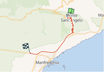

Length
21 km

Max alt
781 m

Uphill gradient
245 m
Km-Effort
26 km

Min alt
29 m

Downhill gradient
925 m
Boucle
No
Creation date :
2024-04-11 16:04:49.211
Updated on :
2024-04-11 16:42:18.501
37m
Difficulty : Very easy

FREE GPS app for hiking
 SityTrail
IGN / Geographical institutes
SityTrail Plus
The world is yours!
About
Trail Car of 21 km to be discovered at Apulia, Foggia, Monte Sant'Angelo. This trail is proposed by DUPORT16.
Positioning
Country:
Italy
Region :
Apulia
Department/Province :
Foggia
Municipality :
Monte Sant'Angelo
Location:
Unknown
Start:(Dec)
Start:(UTM)
579580 ; 4617523 (33T) N.
Comments